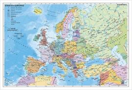
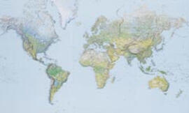
Europe Classic Wandkarte 1:8,425 Mio, Poster 76 x 61 cm, gerollt, Plano in Hülse
Geschenkverpackung verfügbar
Lieferung in 2 bis 5 Werktagen für 8,99 €
oder 6,00 € ab 25,00 € Mindestbestellwert
Lieferung in 2 bis 5 Werktagen für 8,99 €
oder 6,00 € ab 25,00 € Mindestbestellwert
Lieferung in 2 bis 5 Werktagen für 8,99 €
oder 6,00 € ab 25,00 € Mindestbestellwert
Lieferung in 2 bis 5 Werktagen für 2,99 €
oder kostenlos ab 25,00 € Mindestbestellwert
Sie holen das Produkt im Geschäft selbst ab, die Ware liegt in 4 Werktagen für Sie bereit.
Beschreibung
Expertly researched and designed, National Geographic's Europe Wall Map is the authoritative map of Europe by which other reference maps are measured.Product Features:Signature Classic style map with bright, easy to read color palette with blue oceans and colorful bordersBackground shows mountain ranges and valleys in subtle shaded relief with mountain ranges labeledMajor water bodies including rivers, lakes, glaciers, oceans, seas, gulfs, bays, straits, and bathymetryClearly defined international boundaries, cities, islands, airports, and physical featuresThousands of place names carefully and artfully placed to maintain legibility in heavily populated areasUp-to-date international boundaries and territorial control reflect de facto status on the groundMeticulously researched using multiple authoritative sources including the United Nations and policies of individual governments.Accurate place names use a combination of conventional English names, official national names, and standard transliterations for non-Latin alphabets.Countries shown include: Albania, Armenia, Austria, Azerbaijan, Belarus, Belgium, Bosnia & Herzegovina, Bulgaria, Croatia, Cyprus, Czech Republic, Denmark, Estonia, Finland, France, Georgia, Germany, Greece, Hungary, Iceland, Ireland, Italy, Kosovo, Latvia, Liechtenstein, Lithuania, Luxembourg, Moldova, Montenegro, The Netherlands, North Macedonia, Norway, Poland, Portugal, Romania, Russia, Serbia, Slovakia, Slovenia, Spain, Sweden, Switzerland, Turkey, Ukraine, and the United Kingdom.The map is packaged in a two inch diameter tube with a label showing a thumbnail of the map with dimensions and other pertinent information.Map Scale = 1:8,399,000Sheet Size = 30.5 x 23.75
Produktdaten
Produkt teilen
Librairie Ernster
Rue du Fossé 27, L-1536 Luxembourg
Montag 09:00-18:30
Dienstag 09:00-18:30
Mittwoch 09:00-18:30
Donnerstag 09:00-18:30
Freitag 09:00-18:30
Samstag 09:00-18:30